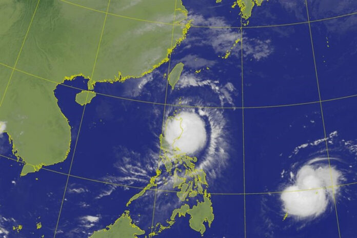
The Central Weather Administration (CWA) has issued a warning regarding the approach of Typhoon Usagi, with the storm’s wind radius expected to hit Taiwan on Friday morning. The typhoon, which is currently located over waters south-southeast of the island, is on track to bring heavy rain, strong winds, and rough seas. While the exact strength of the typhoon and whether it will make landfall remains uncertain, authorities urge residents, especially in coastal areas, to remain vigilant.
Current Typhoon Usagi Status
As of 8 a.m. Thursday, Typhoon Usagi was located approximately 570 kilometers south-southeast of Cape Eluanbi, Taiwan’s southernmost point. The storm’s wind radius extends up to 150 kilometers, and it is moving northwest at 18 kilometers per hour, slowly shifting towards the north-northwest. The maximum sustained winds are clocked at 162 km/h, with gusts reaching up to 198 km/h.
| Parameter | Details |
|---|---|
| Location | 570 km southeast of Cape Eluanbi |
| Wind Radius | 150 km |
| Maximum Sustained Winds | 162 km/h |
| Maximum Gusts | 198 km/h |
| Movement | North-Northwest at 18 km/h |
| Proximity to Taiwan | Expected to reach Taiwan Friday morning |
Expected Impact on Taiwan
Typhoon Usagi’s projected path indicates that its wind radius will reach Taiwan by Friday morning. The Central Weather Administration has raised the alert level for coastal and offshore areas, particularly the Bashi Channel and waters east of the Philippines. The storm’s winds and rough seas are expected to intensify in these areas. Furthermore, swells are anticipated to affect eastern and southwestern Taiwan, the Hengchun Peninsula, as well as the outlying islands of Penghu, Orchid, and Green Island.
Heavy Rain Expected in Southeastern and Eastern Taiwan
Despite the relatively calm weather in much of Taiwan on Thursday, residents in southeastern and eastern parts of the island, particularly near the Hengchun Peninsula and Orchid Island, are advised to prepare for heavy to extremely heavy rain. According to CWA forecaster Wu Wan-hua, this rainfall could intensify as the typhoon nears Taiwan, with localized downpours expected in mountainous regions.
Typhoon Usagi’s Projected Course and Potential Landfall
Wu Wan-hua noted that Usagi is likely to follow a path closer to Taiwan than initially forecasted. The storm is expected to enter the Bashi Channel on Friday, before shifting north-northeast, and then northeastward. While the typhoon is expected to slow down as it nears the island, it will still retain its typhoon status. The CWA has emphasized the importance of continued monitoring, as the exact strength and landfall location of Usagi remain uncertain.
Effects on Pacific Weather Systems
A key factor influencing Usagi’s trajectory is the weakening of the Pacific high-pressure system. As a northern weather system moves southward on Friday and Saturday, it may alter the typhoon’s path. This shifting weather pattern makes it difficult to predict the exact impact and trajectory of the storm in the coming days.
Precautionary Measures and Preparedness
The Central Weather Administration has urged residents to remain vigilant and prepare for possible changes in the typhoon’s behavior. Coastal areas are particularly vulnerable to strong winds and rough seas, while residents in the affected regions should prepare for flash floods and other potential hazards.
FAQs
1. When is Typhoon Usagi expected to reach Taiwan?
Typhoon Usagi’s wind radius is expected to reach Taiwan by Friday morning, with its center likely entering the Bashi Channel.
2. Will Typhoon Usagi make landfall in Taiwan?
It is still uncertain whether Usagi will make landfall in Taiwan. The storm is expected to pass close to the island, but the exact path is still being monitored.
3. What areas will be most affected by Typhoon Usagi?
Southeastern and eastern Taiwan, including the Hengchun Peninsula and Orchid Island, are expected to experience the heaviest rain. Coastal areas are at risk of strong winds and rough seas.
4. Are there any warnings for vessels in the region?
Yes, the CWA has issued warnings for vessels operating in the Bashi Channel and waters east of the Philippines, advising them to remain on alert due to intensifying waves.
5. How can I stay updated on Typhoon Usagi’s progress?
For the latest updates and advisories, please visit the Central Weather Administration’s official website.
Conclusion
As Typhoon Usagi draws closer to Taiwan, the CWA continues to monitor the situation closely. Residents are urged to stay informed, especially in southeastern and eastern regions, where heavy rainfall and strong winds are expected. For further updates on the storm’s progress and safety guidelines, visit CialisWeb.tw.
